GPS/GNSS
GNSS or Global Navigation Satellite System is the generic name for a group of artificial satellites that send timing data to users on earth which can then be used to calculate position.
Although many users refer to the system as GPS the correct name is actually GNSS.
GPS (Global Positioning system) is just one of the many systems that are currently in operation.
- GPS – operated by the United States and was originally set up for the department of defence
- GLONASS – operated by Russia
- BeiDou – operated by China
- Galileo – operated by European Union
- NAVIC – operated by India
- QZSS – Operated by Japan
The basic principle behind the operation of GNSS is fairly straightforward. A signal, with a time stamp, is sent by a satellite (with an exact known position in space). This signal is intercepted by the receiver on earth. The receiver measures the time taken for that signal to reach it and can then calculate the distance of the satellite.
- Distance = Speed x time.
If 3 or more signals are picked up and distances calculated then a position on earth can be plotted by means of Trilateration.
Whilst the above is a relatively basic concept the actual operation of the GNSS systems is very complex.

There are a number of factors that can affect the signal from the GPS and therefore the quality of the distance measurement which in turn affects the accuracy of the position fix.
- Speed of signal – this is assumed to be constant (speed of light) but can be affected as it enters the earth’s atmosphere.
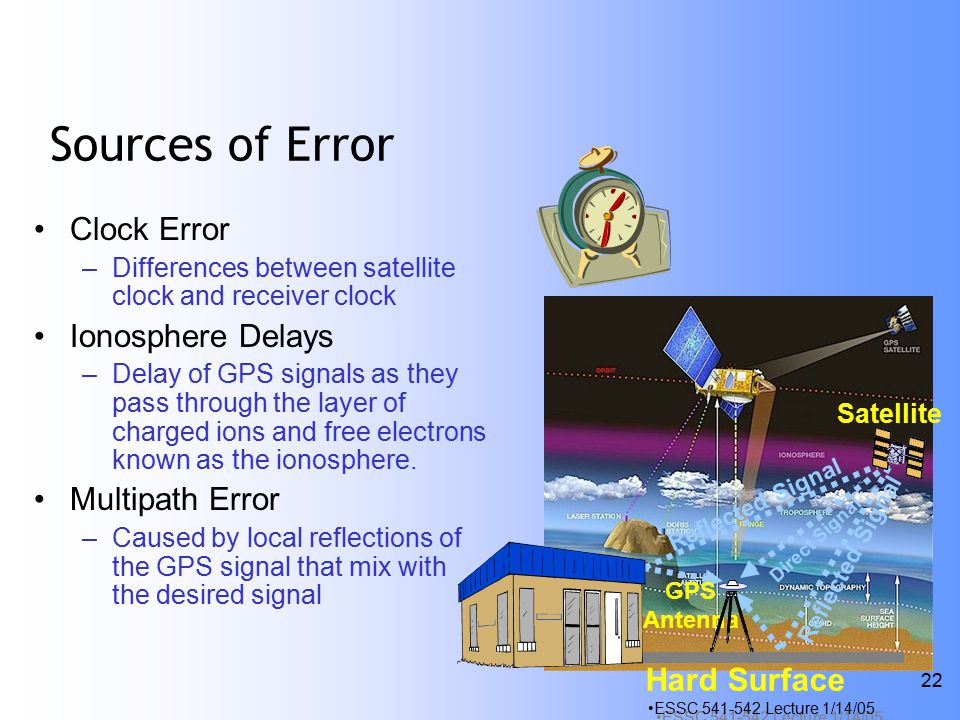
- Signal distortion – especially from satellites low on the horizon. The signal suffers from refraction – the bending of the signal as it passes through layers of atmosphere with different densities.
- Selective availability – the USA used to purposely degrade the signal coming into the receivers (for commercial receivers) in order to degrade the quality of the position. Military GPS units did not suffer from this problem. SA was ceased in 2000.
- Multipath error – this is where the signal bounces off objects before finally arriving at the GPS receiver. This delays the time to reach the receiver and therefore corrupts the distance calculation.
- K-Planetary (KP) Index – This is used to quantify the geomagnetic disturbances around the earth. The KP index scale varies from 0 to 9, with 0 being calm and 9 representing a major storm. Geomagnetic storms are also called Solar storms. The sun follows a roughly 11 year solar cycle and the next peak of this cycle will be around 2025. During times of high solar activity the sun emits large amounts of solar radiation in the form of ultraviolet, x-rays, radiation beams of protons, electrons and other radio waves. When these “eruptions” are directed towards the earth they can disturb our planet’s environment (one of the reasons for the formation of Auroras – northern/southern lights) and can cause issues with GNSS signals or even make them inoperative. Be cautious when flying a drone when the KP Index is higher than 5!
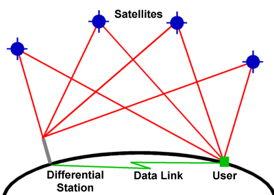
In order to try eliminate or mitigate the above possible errors a system called DGPS was developed (Differential GPS). The basis of this system was to augment the GPS satellite signal with another signal from a known location (eg. a ground station). The differential ground station compares the calculated position from the satellites with its exact known position and applies a necessary correction based on the “difference” between the 2 positions. This correction is then broadcast and in turn is picked up by the GPS receiver. The correction is applied to the calculated position in order to eliminate inaccuracies in the system.
The accuracy of standard GPS positions is generally within a couple of meters but can be reduced to within a few cm with the use of DGPS.
This correction data is usually not a free service. One would typically require a subscription.
Within the aviation sector a Ground Based Augmentation System (GBAS) is often utilized at busier airports to provide correction data to aircraft in the vicinity of the airport in order to improve the accuracy of their GNSS navigational position.
Within the UAV industry the above DGPS system is typically referred to as RTK- Real-time kinematic. It works on the same principle as DGPS does.