Purchase any DJI enterprise/Agricultural drone or payload and receive complimentary access to one of our online courses or a free Advanced license or Level 1 Complex flight review.
Synergy | Productivity |
Safety
Your Trusted Drone Service Experts since 2019
Our business model serves the industry from multiple sides including the Industrial Inspection Service Sector, Training and DJI Enterprise drone sales along with 3rd party parachute systems.
EFFICIENCY | RELIABILITY | INNOVATIVE
Our UAV / drone services cover a cross-section of industries and we can tailor a package for your specific business needs. Let us show you how we can streamline your inspection services in a cost effective manner while reducing operational health and safety risks.
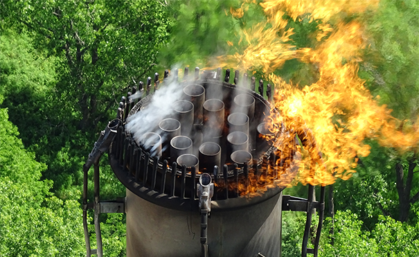
We have over 25 years of combined aviation experience and our knowledge base and use of the latest technology will help save you downtime, provide greater efficiency and remove the human element from safety critical areas that traditional inspection services just cannot match!
TRAINED | CERTIFIED | COMPETENT
Our Transport Canada approved ground school offers both onlineand instructor led courses in the basic, advanced & Level 1 Complex Operations licensing categories as well as personalized flight training, flight reviews and ROC-A examinations. Check out our “Pilot Licensing Process” Page for further information on which license you need.
Dates for our various courses can be found through our training page
Our pilots & instructors are veterans within the industry and will provide the necessary assistance to help you achieve your goals.
Coming in 2026, we are launching our brand new “Professional Industrial Drone Systems Course” which has been built around our years of experience within the industry. The course will be covering in-depth knowledge around Advanced Licensing, Level 1 Complex Operations, Photogrammetry, LiDAR, Thermography, Fixed Wing RPAS Operations, GIS & Control Points, BVLOS, SFOC & SOP Development and Implementation. Contact us for more information.
CLIENTS
Our mission is to always provide our clients with the very best service at competitive pricing and deliver actionable data in a timely manner.
We work with companies of all sizes and strive to turn each project into an ongoing partnership.
Treaty 7 land acknowledgement
In the spirit of reconciliation, we acknowledge that we live, work and play on the traditional territories of the Blackfoot Confederacy (Siksika, Kainai, Piikani), the Tsuut’ina, the Îyâxe Nakoda Nations, the Métis Nation (Region 3), and all people who make their homes in the Treaty 7 region of Southern Alberta.